


Cedar Bluff Voting District, Tazewell County, Virginia
About
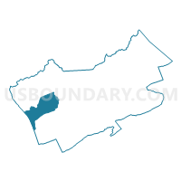
Outline

Summary
| Unique Area Identifier | 682639 |
| Name | Cedar Bluff Voting District |
| County | Tazewell County |
| State | Virginia |
| Area (square miles) | 25.23 |
| Land Area (square miles) | 25.09 |
| Water Area (square miles) | 0.14 |
| % of Land Area | 99.44 |
| % of Water Area | 0.56 |
| Latitude of the Internal Point | 37.08201160 |
| Longtitude of the Internal Point | -81.76650860 |
Maps


Graphs
Select a template below for downloading or customizing gragh for Cedar Bluff Voting District, Tazewell County, Virginia


Neighbors
Neighoring Voting District (by Name) Neighboring Voting District on the Map
- Bandy Voting District, Tazewell County, VA
- Baptist Valley Voting District, Tazewell County, VA
- Elk Garden Voting District, Russell County, VA
- Jewell Ridge Voting District, Tazewell County, VA
- Pounding Mill Voting District, Tazewell County, VA
- Raven Voting District, Tazewell County, VA
- Richlands Voting District, Tazewell County, VA
- Swords Creek Voting District, Russell County, VA
- Wardell Voting District, Tazewell County, VA
Top 10 Neighboring County Subdivision (by Population) Neighboring County Subdivision on the Map
- Lebanon district, Russell County, VA (14,477)
- Northern district, Tazewell County, VA (9,243)
- Northwestern district, Tazewell County, VA (8,882)
- Western district, Tazewell County, VA (8,841)
- New Garden district, Russell County, VA (7,347)
Top 10 Neighboring Place (by Population) Neighboring Place on the Map
- Richlands town, VA (5,823)
- Raven CDP, VA (2,270)
- Claypool Hill CDP, VA (1,776)
- Cedar Bluff town, VA (1,137)
Top 10 Neighboring Unified School District (by Population) Neighboring Unified School District on the Map
Top 10 Neighboring State Legislative District Lower Chamber (by Population) Neighboring State Legislative District Lower Chamber on the Map
Top 10 Neighboring State Legislative District Upper Chamber (by Population) Neighboring State Legislative District Upper Chamber on the Map
Top 10 Neighboring 111th Congressional District (by Population) Neighboring 111th Congressional District on the Map
Top 10 Neighboring Census Tract (by Population) Neighboring Census Tract on the Map
- Census Tract 203, Tazewell County, VA (6,701)
- Census Tract 301, Russell County, VA (4,672)
- Census Tract 204, Tazewell County, VA (4,385)
- Census Tract 206, Tazewell County, VA (4,358)
- Census Tract 210, Tazewell County, VA (4,234)
- Census Tract 205, Tazewell County, VA (3,152)
- Census Tract 304.02, Russell County, VA (3,065)